- Joined
- May 6, 2006
- Messages
- 4,208
- Reaction score
- 3
Hey guys,
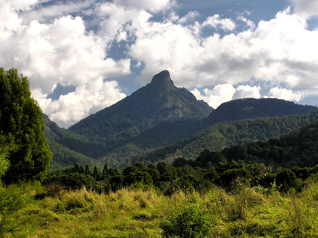
What an amazing weekend I've had. On Saturday Jo & I drove down to Mt Warning national park, with the intention of climbing the mountain before dawn on Sunday, to watch the sunrise. It was such a great experience, and the physical exersion of getting up there was definatly worth the view once we were on top. Mt Warning is the rooftop of Australia's Eastern Coast. It is the first place in Australia the sun hits.
We left Brisbane at 2:30pm, and headed down the coast. You can get to national park by taking the highway straight to Murwillumba, but we were following instructions done up by a friend of mine who's in the MX5 car club. What does that mean? It means if there's a longer, but more "fun" way of getting to the destination, it will be chosen over the shorter more direct route.
As we headed down the Pacific Highway, we took the Tullabugera exit. At this point I didn't realise what lay ahead, and thought it was a bit strange that the directions we were given were not the most direct route to Murwillumba. We started going up hill, and I thought "This looks like fun", and then I saw one of the best signs any driver can see on a road. "Drive to conditions". That means...NO SPEED LIMIT.
We were now crossing the McPherson Range, and ohh boy was it something special. I felt like Takumi in Initial D. What an awesome peice of road that is. Corner after corner, cambered bank after cambered bank. Uphill, downhill, hard on the accelerator, hard on the brake, shift down 2 gears, power out of the corner with the rear just slipping out a little, straighten the car...power on to the next gear, back on the brake ready to enter the next corner. This went on and on for 8 maybe 10 kilometers. Up through the range, then down the other side...with no fear of a police radar. Jo was in the passenger seat of the S15, and we both had MASSIVE grins on our faces. She could tell I was enjoying myself. It really was one of the best mountain runs I've been on.
What a great way to start the weekend.
After that we continued the drive to Mt Warning National Park where we setup camp with the couple who we were meeting there (Adam & Wendy). They'd already been there from the day before, and already had our camp spot booked.
The actual camp ground is very well setup, with full ameneties (hot showers, clean toilets, kitchen & bbq area) etc etc. And every site has its own "fire pit" for your camp fire. What is almost the start of the Tweed River runs through the camp ground, so the sound of running water over rocks adds to the ambience of the experience. We setup our tent, and started to prepare for dinner.
After a nice BBQed meal of rib eye fillet, home made pasta salad and potatoe salad - I kicked back into a couple of glasses of red wine before going to bed early and trying to get some sleep. I say "try" because it was only about 8pm, and the rest of the camp site was still awake. I got a couple of hours sleep but it was interruped during the night by people moving their cars, or kids playing a few camp sites up. Also there was a guy next to us who sounded like he was dying when he snored.
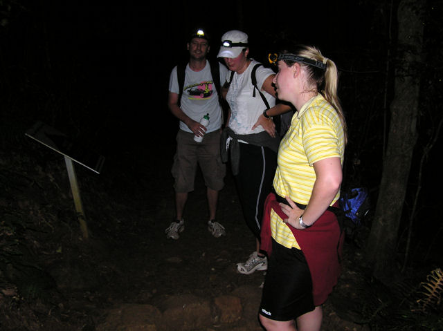
At 3am on Sunday morning, we woke up, packed the car with our gear and headed off to the base of Mt Warning. From the camp site, its around 3km to drive to the carpark where the trail begins. Now remember this point. As we were driving up to the carpark, we passed a couple who were walking to the carpark itself. They looked hardcore with all their gear, their walking poles, and matching jacket & pants. Ok so remember that... we drove past them, and effectively had a 2.5km head start.
Once we were at the carpark we put on our bags, our headlights, checked the time (3:25am) and started the trek. The hike is 8.8km return (4.4km each way). And it is pretty much, straight up. Its by no means an easy trek, and is classed as "strenuous". The path takes you through some ancient rainforest, with MASSIVE trees. I mean.._MASSIVE_. Trees that would have been there 10,000yrs+ Some serious coffee tables there. Stepping up the path that zig-zags the side of Mt Warning took its toll on us. Just a mere 300-400m into the track we were already panting. That doesn't sound like far, but its a long way when you're pretty much walking straight up the side of a mountain. The path is rough and is covered with rocks. So you do have to be mindful of where you're stepping.
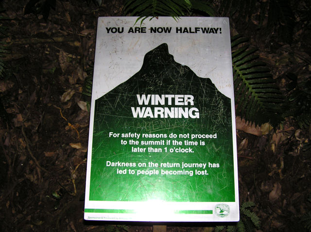
1hr into the walk up, we reached the halfway point. At this stage we were almost exhausted, and we were only half way.
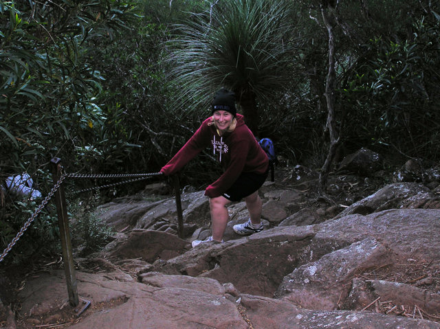
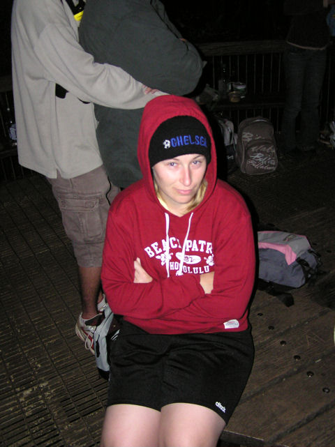
While the trek up takes 2hrs, it only takes 1.5hrs to get to the "rock wall". The Rock Wall is a near vertical climb up a wall of rock. You cannot walk up it, rather you need to climb up it on your hands and feet, or use the chain to pull yourself up. This wall is 100m straight up, and took us approximately 30mins. While this photo was taken on the way down, you can see the steepness of the wall. That chain Jo is holding onto is the only thing that'll stop you from a nasty fall.
At 5:30am we reached the summit. We were all completely exhausted, and it was freezing. You could feel the air get colder as you accented, and breathing also got harder. Keeping a constant pace, but stopping every 15mins to get our breath back and to have some water...we made the trek in 2hrs 5mins. Remember that couple we drove past earlier? They arrived at the summit about 10mins after we did. HARDCORE!
There is a viewing platform up the top, and a path that walks around the summit so you can get 360 degree views. Sunrise was scheduled for 6:05am. While waiting for the first glow of sunrise to come over the ocean - the cold started getting to Jo.
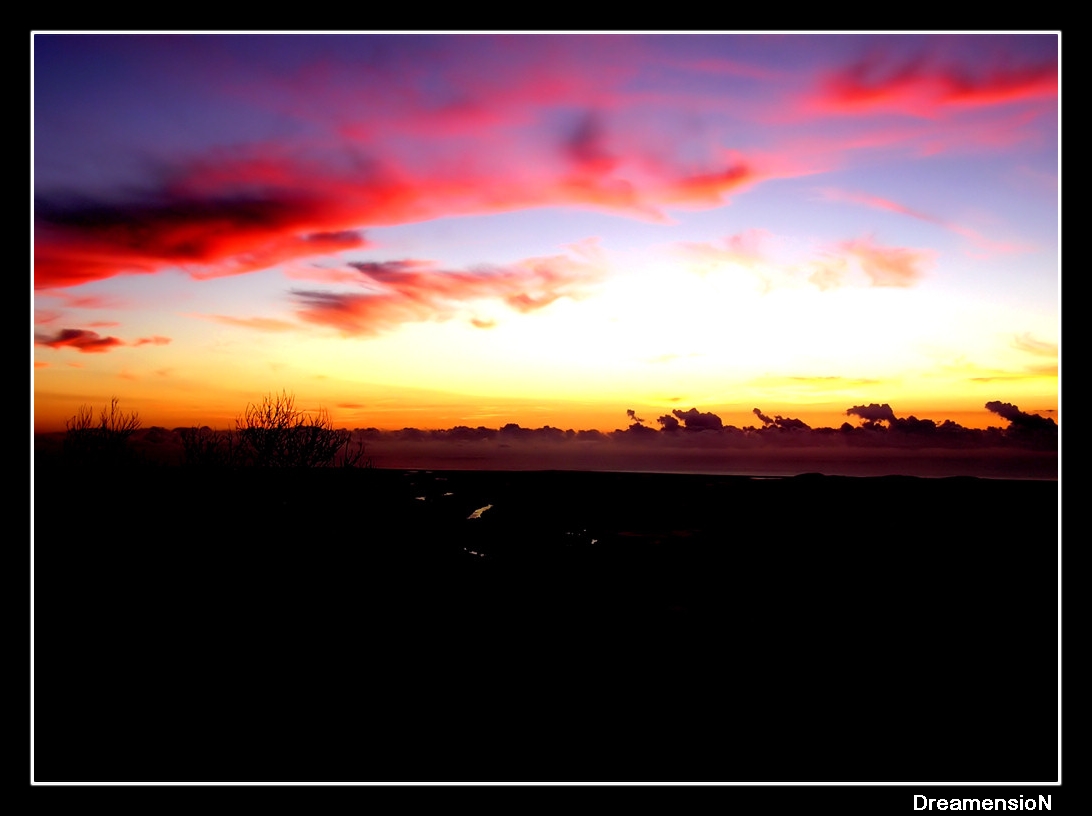
Then it started... the first hues and glow of sunrise. Watching the sunrise from so high up is an amazing experience, and something I won't forget. This is a photo of pre-dawn.
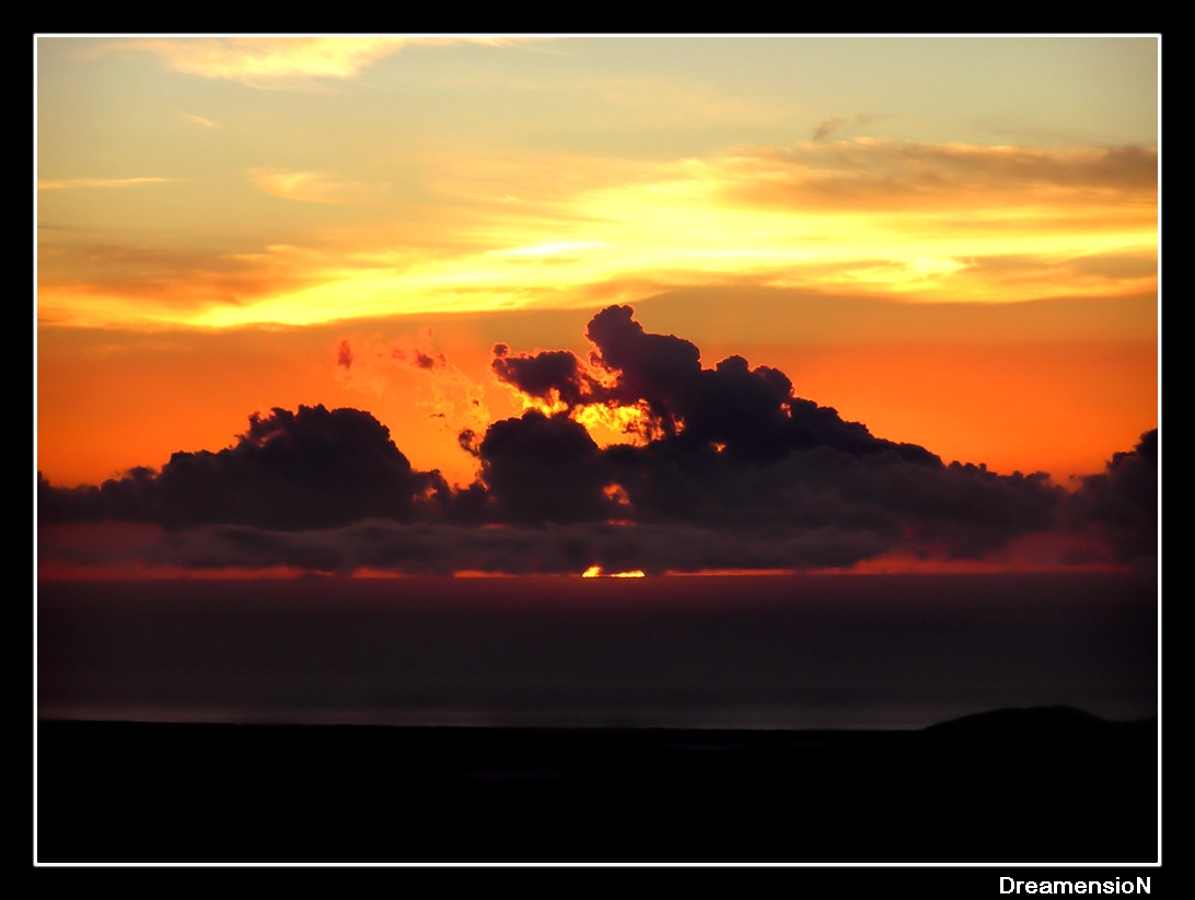
Then it happened... sunrise. You can see here the first rays of sun coming over the ocean, between the ocean and the clouds.

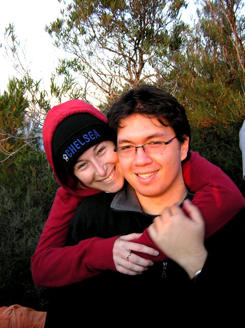
Me and Jo in the first rays of sunlight across Australia
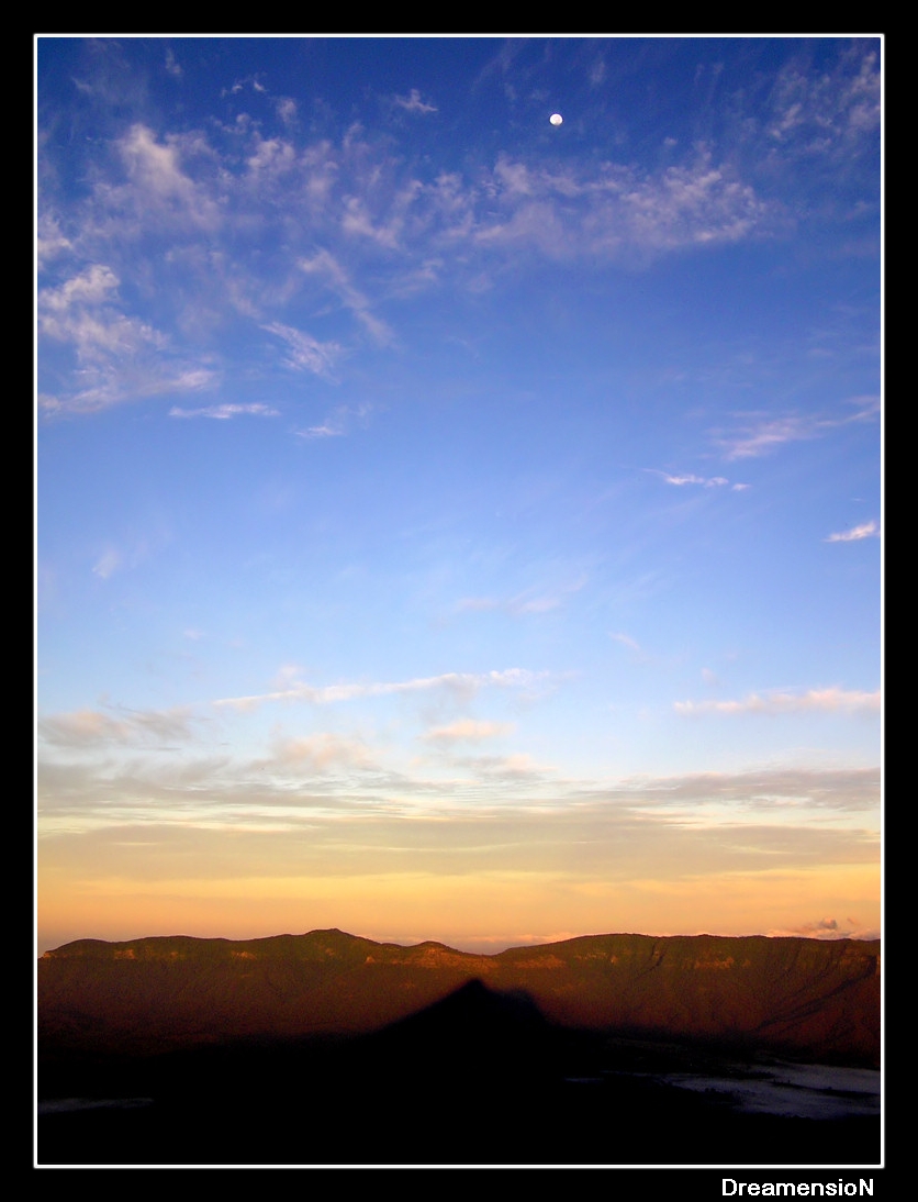
As the sun rose, it started to illuminate the views we had. This photo was taken looking west. You can see the moon and the shadow of Mt Warning created on the mountain range behind it.
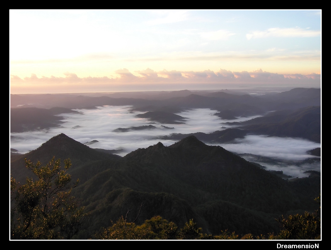
In this photo - you can see the fog in the valleys below. And if you look along the coast line, you can see Byron Bay jutting out. A bit later in the morning with binoculars, you could see the lighthouse.
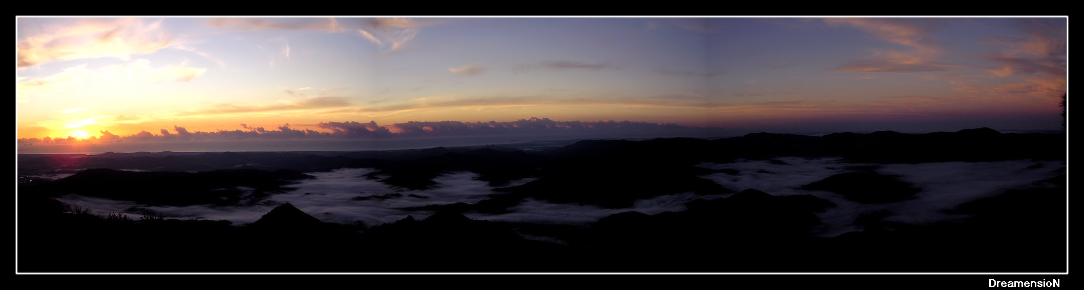
This photo is a panorama of the sunrise. Its been stiched together in the dodgy Olympus program I use with my camera, but one day I'll get it properly done and printed.
At 7am we left the summit for the trek down. Going down is a lot easier than coming up, but it still took 1hr 45mins to complete the decent to the carpark. We got back to camp at around 9am, for a hot shower, then a hearty breakfast of bacon, eggs & baked beans. Never in my life have I been so physically smashed from a trek. I'm still feeling it now. But what a journey!
The rest of the day was spent snoozing, eating, snoozing some more, and then heading into town for iced coffee's just after lunch. We started packing up our tent at 3pm, and loaded the car for the drive home. On the way back, we had the option of going through Murwillumba and getting back onto the highway straight home (we were still totally flogged), or going back over the mountain range once more.
Which one do you think I picked?
What an amazing weekend I've had. On Saturday Jo & I drove down to Mt Warning national park, with the intention of climbing the mountain before dawn on Sunday, to watch the sunrise. It was such a great experience, and the physical exersion of getting up there was definatly worth the view once we were on top. Mt Warning is the rooftop of Australia's Eastern Coast. It is the first place in Australia the sun hits.
We left Brisbane at 2:30pm, and headed down the coast. You can get to national park by taking the highway straight to Murwillumba, but we were following instructions done up by a friend of mine who's in the MX5 car club. What does that mean? It means if there's a longer, but more "fun" way of getting to the destination, it will be chosen over the shorter more direct route.
As we headed down the Pacific Highway, we took the Tullabugera exit. At this point I didn't realise what lay ahead, and thought it was a bit strange that the directions we were given were not the most direct route to Murwillumba. We started going up hill, and I thought "This looks like fun", and then I saw one of the best signs any driver can see on a road. "Drive to conditions". That means...NO SPEED LIMIT.
We were now crossing the McPherson Range, and ohh boy was it something special. I felt like Takumi in Initial D. What an awesome peice of road that is. Corner after corner, cambered bank after cambered bank. Uphill, downhill, hard on the accelerator, hard on the brake, shift down 2 gears, power out of the corner with the rear just slipping out a little, straighten the car...power on to the next gear, back on the brake ready to enter the next corner. This went on and on for 8 maybe 10 kilometers. Up through the range, then down the other side...with no fear of a police radar. Jo was in the passenger seat of the S15, and we both had MASSIVE grins on our faces. She could tell I was enjoying myself. It really was one of the best mountain runs I've been on.
What a great way to start the weekend.
After that we continued the drive to Mt Warning National Park where we setup camp with the couple who we were meeting there (Adam & Wendy). They'd already been there from the day before, and already had our camp spot booked.
The actual camp ground is very well setup, with full ameneties (hot showers, clean toilets, kitchen & bbq area) etc etc. And every site has its own "fire pit" for your camp fire. What is almost the start of the Tweed River runs through the camp ground, so the sound of running water over rocks adds to the ambience of the experience. We setup our tent, and started to prepare for dinner.
After a nice BBQed meal of rib eye fillet, home made pasta salad and potatoe salad - I kicked back into a couple of glasses of red wine before going to bed early and trying to get some sleep. I say "try" because it was only about 8pm, and the rest of the camp site was still awake. I got a couple of hours sleep but it was interruped during the night by people moving their cars, or kids playing a few camp sites up. Also there was a guy next to us who sounded like he was dying when he snored.
At 3am on Sunday morning, we woke up, packed the car with our gear and headed off to the base of Mt Warning. From the camp site, its around 3km to drive to the carpark where the trail begins. Now remember this point. As we were driving up to the carpark, we passed a couple who were walking to the carpark itself. They looked hardcore with all their gear, their walking poles, and matching jacket & pants. Ok so remember that... we drove past them, and effectively had a 2.5km head start.
Once we were at the carpark we put on our bags, our headlights, checked the time (3:25am) and started the trek. The hike is 8.8km return (4.4km each way). And it is pretty much, straight up. Its by no means an easy trek, and is classed as "strenuous". The path takes you through some ancient rainforest, with MASSIVE trees. I mean.._MASSIVE_. Trees that would have been there 10,000yrs+ Some serious coffee tables there. Stepping up the path that zig-zags the side of Mt Warning took its toll on us. Just a mere 300-400m into the track we were already panting. That doesn't sound like far, but its a long way when you're pretty much walking straight up the side of a mountain. The path is rough and is covered with rocks. So you do have to be mindful of where you're stepping.
1hr into the walk up, we reached the halfway point. At this stage we were almost exhausted, and we were only half way.
While the trek up takes 2hrs, it only takes 1.5hrs to get to the "rock wall". The Rock Wall is a near vertical climb up a wall of rock. You cannot walk up it, rather you need to climb up it on your hands and feet, or use the chain to pull yourself up. This wall is 100m straight up, and took us approximately 30mins. While this photo was taken on the way down, you can see the steepness of the wall. That chain Jo is holding onto is the only thing that'll stop you from a nasty fall.
At 5:30am we reached the summit. We were all completely exhausted, and it was freezing. You could feel the air get colder as you accented, and breathing also got harder. Keeping a constant pace, but stopping every 15mins to get our breath back and to have some water...we made the trek in 2hrs 5mins. Remember that couple we drove past earlier? They arrived at the summit about 10mins after we did. HARDCORE!
There is a viewing platform up the top, and a path that walks around the summit so you can get 360 degree views. Sunrise was scheduled for 6:05am. While waiting for the first glow of sunrise to come over the ocean - the cold started getting to Jo.
Then it started... the first hues and glow of sunrise. Watching the sunrise from so high up is an amazing experience, and something I won't forget. This is a photo of pre-dawn.
Then it happened... sunrise. You can see here the first rays of sun coming over the ocean, between the ocean and the clouds.
Me and Jo in the first rays of sunlight across Australia
As the sun rose, it started to illuminate the views we had. This photo was taken looking west. You can see the moon and the shadow of Mt Warning created on the mountain range behind it.
In this photo - you can see the fog in the valleys below. And if you look along the coast line, you can see Byron Bay jutting out. A bit later in the morning with binoculars, you could see the lighthouse.
This photo is a panorama of the sunrise. Its been stiched together in the dodgy Olympus program I use with my camera, but one day I'll get it properly done and printed.
At 7am we left the summit for the trek down. Going down is a lot easier than coming up, but it still took 1hr 45mins to complete the decent to the carpark. We got back to camp at around 9am, for a hot shower, then a hearty breakfast of bacon, eggs & baked beans. Never in my life have I been so physically smashed from a trek. I'm still feeling it now. But what a journey!
The rest of the day was spent snoozing, eating, snoozing some more, and then heading into town for iced coffee's just after lunch. We started packing up our tent at 3pm, and loaded the car for the drive home. On the way back, we had the option of going through Murwillumba and getting back onto the highway straight home (we were still totally flogged), or going back over the mountain range once more.
Which one do you think I picked?