Kiritimati
From Wikipedia, the free encyclopedia
For the island in the Indian Ocean, see Christmas Island.
Coordinates: 1°52′N 157°24′W
Kiritimati or Christmas Island is a Pacific Ocean atoll in the northern Line Islands and part of the Republic of Kiribati.
The island has the greatest land area of any coral atoll in the world: about 322 square kilometres (124 sq mi)[1]; its lagoon is about the same size. The atoll is about 150 km (93 mi) in perimeter, while the lagoon shoreline extends for over 48 km (30 mi).[2] Kiritimati comprises over 70% of the total land area of Kiribati, a nation encompassing 33 Pacific atolls and islands.
It lies 232 km (144 mi) north of the Equator, 6,700 km (4,200 mi) from Sydney, and 5,360 km (3,330 mi) from San Francisco. Kiritimati is the first inhabited place on Earth to experience the New Year each year (see also Caroline Atoll, Kiribati).
Despite being 1,530 miles (2,460 km) east of the 180 meridian, a 1995 realignment of the International Dateline by the Republic of Kiribati "moved" Kiritimati to west of the dateline.
Nuclear tests were conducted in the region around Kiritimati by the United Kingdom in the late 1950s. During these tests islanders were not evacuated. Subsequently British, New Zealand and Fijian servicemen as well as local islanders have claimed to have suffered from exposure to the radiation from these blasts.
The entire island is a Wildlife Sanctuary; access to five particularly sensitive areas (see below) is restricted.[1]
The name "Kiritimati" is a rather straightforward transliteration of the English word "Christmas" into Gilbertese – where the 'ti' combination is pronounced 's' – and thus pronounced [kəˈrɪsməs]. Similarly Kiribati is a transliteration of Gilberts with the K replacing the G and the R replacing the L.
This part of the Republic of Kiribati is in the world's furthest forward time zone, UTC+14.

")


 the islands are quite beautiful.

 :grinning:


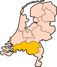
 the most densely populated parts of the small country at the mouth of rivers Rhine, Maas and Schelde. The most wealthy and ( political ) influencial ones too. The bigger cities Amsterdam, Rotterdam and The Hague are all in North and South Holland Provinces. In sòme parts of history, because of the lets say : ' dominance ' of the two provinces, the whole country was called ' Holland '. Holland derives from ' Holt land ' ( = wood land ) for in ancient times, there were woods and wet marshlands. Result of low lying area, and the mouth of rivers + sea tides